Bushfire.io and Flightradar24
- Disaster Science
- Bushfire.io
- February 9, 2023
Table of Contents
Our Partnership
Bushfire.io has partnered with Flightradar24 to provide real-time tracking of emergency response aircraft. Flightradar24 hosts the largest ADS-B network in the world, providing unrivalled coverage of the USA, Canada and Australia. This helps us to better meet our goal of better serving regional and remote areas, improving the level of information available when facing a natural disaster. You’ll be able to see more aircraft flying, helping to keep people safe!
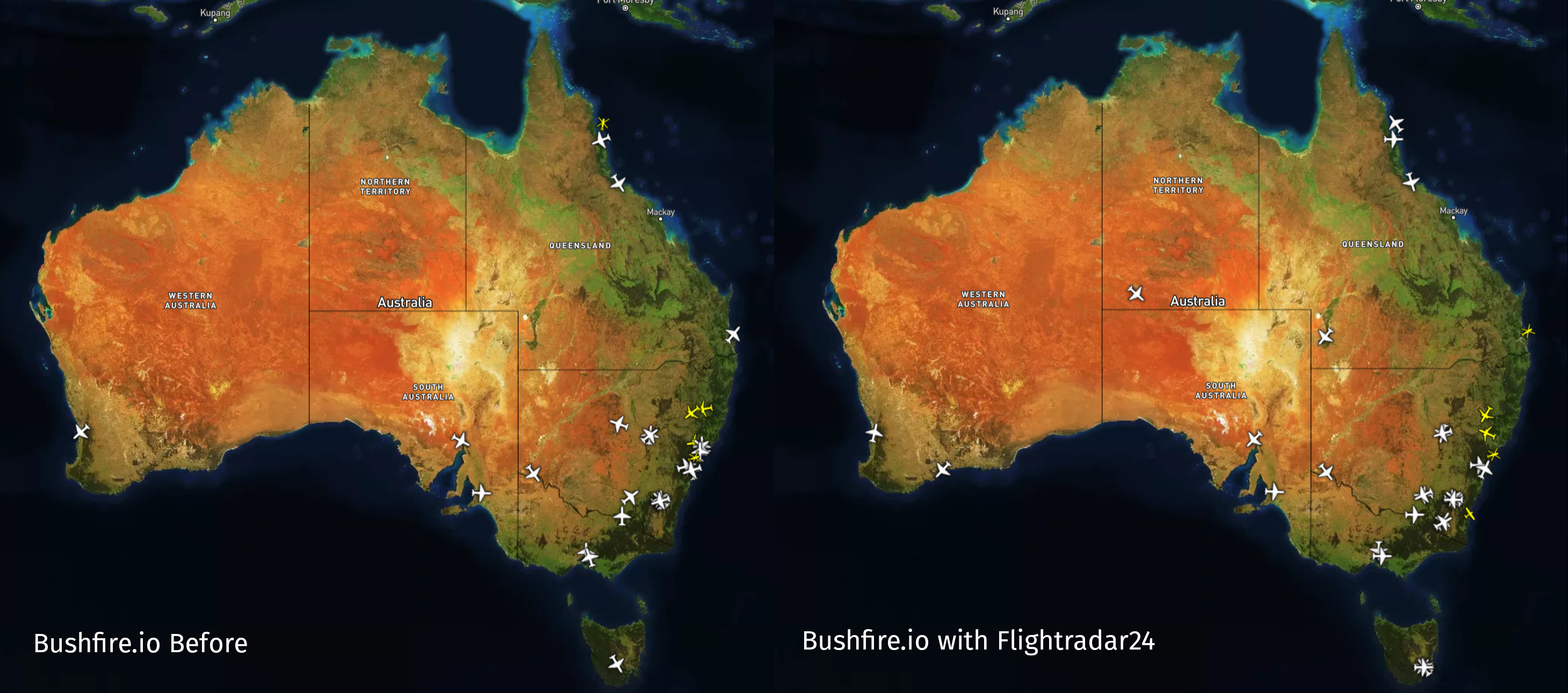
While our partnership with Flightradar24 is a big step forward, we still need your help to improve coverage in remote areas (usually 200km+ from the Australian coast) even more. If you simply live in these areas, or have physical access please help us to improve coverage. You can do this in three steps:
- Learn more about hosting a receiver.
- Submit an application (preference is given to people in regional and remote areas) or build your own today. If you submit an application, please send a request to us and we’ll try to bump it up the priority list. Receivers (including build your own) who share their data with Flightradar24 receive access to their complimentary FR24 (business plan)[https://www.flightradar24.com/premium].
Aircraft on Bushfire.io
To see an aircraft on Bushfire.io, a few things have to happen:
- The aircraft must be special to us, it must be a known emergency response aircraft.
- The aircraft must be operational/flying.
- The aircraft must be operating with ADS-B transceivers.
- The aircraft must be operating within the Flightradar24 coverage areas, usually up to ~250km (155mi) of a receiving station. Hills and mountains can interfere with radio signals and coverage. Click here to help improve our coverage.
What are known emergency response aircraft?
We maintain a database of “known emergency response aircraft” which support emergency response efforts in Australia, Canada and the USA. Aircraft are either registered directly with us, or the Australian National Aerial Firefighting Centre (NAFC). If the aircraft is contracted by NAFC, it is likely already in our database unless it is recently registered. You can check the NAFC call sign list.
If the aircraft is missing from NAFC, or contracted under alternate arrangements please contact us and provide the aircraft’s registration and ICAO24 code.
Why does it appear like there aren’t any aircraft operating?
This could be due to a few reasons:
- If you have seen aircraft operating previously in the area, it’s likely the aircraft are not currently tasked, visibility is poor (most fire aircraft require visual flight conditions to operate), or the aircraft operating do not have ADS-B.
- If you have not seen aircraft operating previously in the area and you know there are aircraft in the area, it’s likely there is insufficient coverage in the area, or the aircraft operating do not have ADS-B.