Disasters can strike at any moment. Whether you’re a solo adventurer seeking peace of mind, a small business safeguarding staff and customers, or a large organisation managing critical infrastructure, we have a plan tailored to your needs.
Bushfire.io Always Free
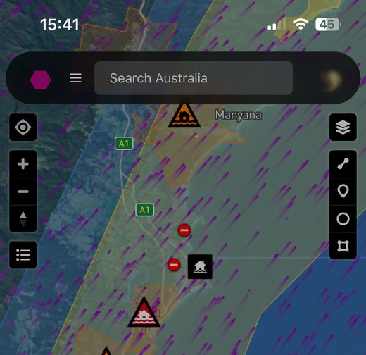
Stay informed about fires, floods, storms, and other disasters in Australia, Canada, and the United States without paying a cent. Our free tier ensures everyone can access essential information to make safer decisions.
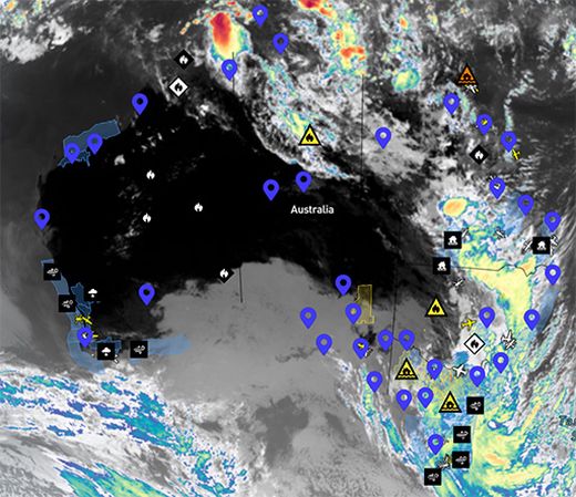
- Real-Time Situational Awareness: Monitor incidents on a live map for quick updates. Seamlessly move from a national view to see what’s happening next door.
- Alerts & Notifications: Set up to 5 notifications on Android, iOS, PC, or Mac within a 75 km circle. Notification setup guide.
- Basic Drawing Tools: Sketch and measure on the map to mark areas of concern.
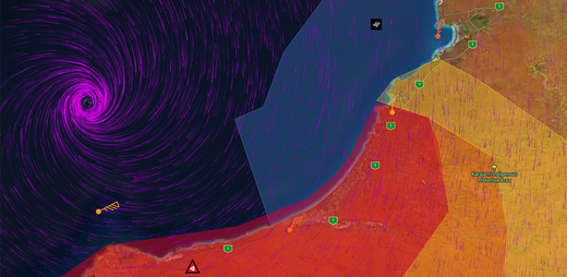
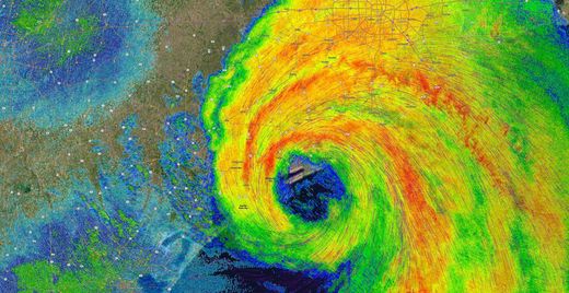
- Low-Resolution Wind Forecast: 3-hourly data from NOAA’s Global Forecast System (GFS). Learn about wind models.
Bushfire.io Pro
Perfect for dedicated individuals and community members who want deeper insights, higher-resolution wind models, and more robust alerting options—all within the same easy-to-use app.
- Possible Fire Ignitions: See where lightning may have ignited a new fire, before fire agencies. Learn More.
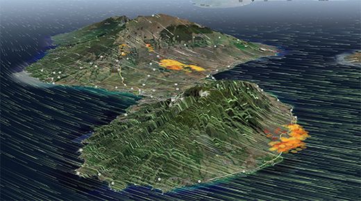
- 3D Wind & Terrain: Visualise how geography influences disaster movement. See a Demo!.
- Lightning: See where positive lightning strikes might start a fire. You can also see cloud-to-cloud and negative strikes.
- High-Resolution Wind Forecasts: Hourly data from BOM’s ADFD (~6 km) or NOAA’s HRRR (~3 km). Learn about wind models.
- Historical Data: Examine incidents up to 1 month in the past, with hourly increments via Time Machine.
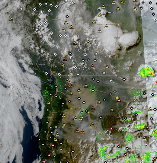
- Near Real-Time Satellite Imagery View what is happening on the ground, with a delay of ~10-20 minutes. See true-colour, or false-color for storms, smoke, fire edges and dust. Learn about satellite imagery.
- Up to 25 Notifications: Configure multiple alerts for different locations or custom shapes.
- All Features from Free: Enjoy real-time awareness plus more advanced capabilities.
Bushfire.io Business
Designed for commercial entities, government agencies, and small teams seeking a collaborative approach to disaster management. Monitor shared points of interest, assign user roles, and streamline critical alerts for your entire organisation.
- Team Management: Share custom layers containing points-of-interest, and use those POIs to notify staff. Learn about managing users.
- Organisational Alerts: Automate notifications to protect people, infrastructure, and assets. Learn about custom layers.
- Extended Time Machine: Access historical, high-resolution data for the past 12-months.
- Everything from Pro: Access advanced wind and terrain features plus extended collaboration.
Bushfire.io Enterprise
Enterprise-grade disaster management with ultimate flexibility, scalability, and control. Designed for organisations needing robust integrations, custom deployment, and high-performance infrastructure. No per-user limits – manage your team your way.
- Unified Data Streams: REST APIs and webhooks provide incidents, road closures, weather, and Possible Fire Ignitions directly into your systems.
- Company-Wide Licensing: One subscription for your whole organisation – no per-user billing. Learn about licencing.
- Advanced Admin Tools: Control user access, permissions, and data visibility from a central dashboard. Learn about managing users.
- Cloud & Whitelabel: Launch custom-branded web, iOS, and Android apps scaled to millions of users.
- Raw Data Access: Ingest unfiltered, high-frequency datasets for advanced internal analytics and modelling.
- GIS Compatibility: Use WMS/WFS endpoints for real-time data in ESRI, QGIS, and other mapping platforms.
- Custom Engineering: Engage our team for bespoke feature development and integration with platforms like Battleground.
- Priority Support & SLAs: Onboarding help, dedicated response times, and custom service-level agreements included.
Bushfire.io Cloud
Deploy your own scalable, branded instance of Bushfire.io—ideal for public agencies, corporations, or large-scale events. Take full control of the experience, while we manage hosting, updates, and reliability behind the scenes.
- Whitelabel Deployment: Run Bushfire.io on your own domain with custom branding across web, iOS, and Android apps.
- Flexible Admin Tools: Control access, customise map layers, and manage data visibility to suit your organisation’s needs.
- Author Local Warnings: Publish internal advisories or regional updates for staff, partners, or the public.
- Massive Scale, No Hassle: Our infrastructure supports millions of users with high reliability and speed.
- GIS-Ready: Seamlessly integrate with ESRI and other platforms to enrich public maps or internal dashboards.
- Custom Features: Work with us to adapt the platform for your workflows, data sources, and audience.
Bushfire.io Developers
Our developer docs are your gateway to leveraging our RESTful APIs, webhook events, and data. If you’re looking to integrate real-time disaster intelligence into your own applications or services, our developer docs provide the tools and resources to make it happen. Need access? Get in touch to discuss your project ideas or learn more about enterprise-grade integrations. Your vision and creativity can help build solutions that truly make a difference.
- Explore Our API: Delve into the documentation for incident data, wind forecasts, and more.
- Webhook Events: Receive push notifications for critical updates directly into your application.
- Tailored Integrations: Work with us to design custom endpoints, unique data streams, or advanced GIS solutions.
| Feature | Always Free | Pro | Business | Cloud | Enterprise |
|---|---|---|---|---|---|
| Situational Awareness | |||||
| Complete Awareness Platform | ✅ | ✅ | ✅ | ✅ Volume | ✅ |
| Mobile Apps | ✅ | ✅ | ✅ | ✅ Customised | ✅ |
| Drawing Tools | ✅ | ✅ | ✅ | ✅ | ✅ |
| Layer Control | ✅ | ✅ | ✅ | ✅ | ✅ |
| Elevation Info | ✅ | ✅ | ✅ | ✅ | |
| Wind Forecast | GFS 1.0deg | GFS 0.25deg HRRR NAM ADFD | GFS 0.25deg HRRR NAM ADFD | GFS 0.25deg HRRR NAM ADFD | GFS 0.25deg HRRR NAM ADFD |
| 3D Wind & Terrain | ✅ | ✅ | ✅ | ✅ | |
| Flat-Earth View | ✅ | ✅ | ✅ | ✅ | ✅ |
| 3D Globe View | ✅ | ✅ | ✅ | ✅ | |
| Lightning Info | ✅ | ✅ | ✅ | ||
| Time Machine | 30 days | 1 year | 1 year (*) | 1 year (*) | |
| Light/Dark Maps | ✅ | ✅ | ✅ | ✅ | |
| Notification Engine | |||||
| All-Platform Push | ✅ | ✅ | ✅ | ✅ | ✅ |
| SMS | ✅ | ✅ | ✅ Volume | ✅ | |
| Linked-Email | ✅ | ✅ | ✅ Volume | ✅ | |
| Any-Email | ✅ | ✅ Volume | ✅ | ||
| Webhooks | ✅ Volume | ✅ | |||
| Max Rules | 5 | 25 | 25 | 25 | 25 |
| Search for Location | ✅ | ✅ | ✅ | ✅ | ✅ |
| Distance-Based Alerts | 75km | 75km | 75km | 75km | 75km |
| Polygon-Based Alerts | - | Unlimited | Unlimited | Unlimited | Unlimited |
| Custom Layers | |||||
| View Layers | ✅ | ✅ | ✅ | ✅ | |
| Create Layers | ✅ | ✅ | ✅ | ||
| Receive Layer Alerts | ✅ | ✅ | ✅ | ||
| Configure Layer Alerts | ✅ | ✅ | ✅ | ||
| Licencing | |||||
| Manage Licences | ✅ | ✅ | ✅ | ||
| Manage Users | ✅ | ✅ | ✅ | ||
| Data | |||||
| API Access | ✅ | ✅ | ✅ | ✅ | ✅ |
| GeoJSON / Pull | ✅ | ✅* | |||
| Websocket / Push | ✅ | ✅ | |||
| GIS (WMS/WFS) | ✅* | ✅* | |||
| Cloud Instance | |||||
| Own Instance | ✅ | ||||
| Use Your Own Domain | ✅ | ||||
| Customise Branding | ✅ | ||||
| Incident Authoring | |||||
| Author Alerts | ✅ | ✅# | |||
| Preview Alerts | ✅ | ✅# | |||
| Send Notifications | ✅ | ✅# | |||
| Event Management | ✅ | ✅# | |||
| Public Messaging | ✅ | ✅# | |||
| Support | |||||
| Standard | ✅ | ✅ | ✅ | ✅ | ✅ |
| Priority | ✅* | ✅* | ✅* | ||
| SLA | ✅* | ✅* | ✅* |
✅ = Enabled, * = Addon, # = Approval required.
Not Sure Which Plan Fits Your Needs?
Explore Our Solutions by Industry to see how we address challenges in sectors like telecommunications, critical infrastructure, emergency services, and more.
Contact us at [email protected] for a custom package, volume licensing, or a fully white-labeled platform. We’re here to help you protect what matters most—every day, everywhere.